-40%
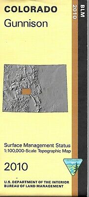
BLM Map of Gunnison, Colorado, by US Dept of the Interior
$ 2.61
- Description
- Size Guide
Description
BLM Map of Gunnison, Colorado, by US Dept of the InteriorThe BLM quadrant maps are scaled at 1:100,000, and cover an area of about 30 x 50 miles. Beauty abounds in this area which includes the Gunnison National Forest and the San Isabel National Forest as well as the Collegiate Peaks Wilderness, the Fossil Ridge Wilderness, Buffalo Peaks Wilderness, and the Maroon Bells Snowmass Wilderness. Map also includes a section of the Arkansas River with campgrounds, fishing accesses, and river accesses for floating/rafting. Fishing, boating, and camping at Taylor Park Reservoir. Map is useful for OHV use, and Colorado Hunting Units 48, 49, 54, 55, 56, 57, 481, and 551. Ownership status is denoted by color, and roads, lakes, streams, and other topographical features are marked on these maps. 2010
Colorado: Highways, roads, and other manmade structures, water features, contours and elevation in meters. Plus recreational sites. Other activities include camping in some wildlife areas, wildlife viewing, and hiking. Official BLM Map shows color-coded federal, state, and private lands, topographic detail, roads, water features, recreation sites, points of interest, place names, county boundaries, and township and range lines. Scale is 1:100,000, roughly 3/4 inch to 1 mile.
Printed in the U.S.A. and measures 40" x 36"
Published by the US Forest Service, 2010 US Dept. of the Interior Bureau of Land Management
