-40%
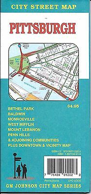
City Street Map of Pittsburgh, Pennsylvania, by GMJ Maps
$ 3.14
- Description
- Size Guide
Description
City Street Map of Pittsburgh, Pennsylvania, by GMJ MapsA detailed and up to date city street map of
Pittsburgh, Pennsylvania
.
Also covers;
Aspinwall, Avalon, Baldwin, Bellevue, Ben Avon, Bethel Park, Blawnox, Brackenridge, Braddock, Braddock Hills, Brentwood, Bridgeville, Carnegie, Castle Shannon, Chalfant, Churchill, Clairton, Crafton, Dormont, Dravosburg, Duquesne, East McKeesport, East Pittsburgh, Edgewood, Edgeworth, Etna, Forest Hills, Fox Chapel, Glassport, Greentree, Heidelburg, Homestead, Ingram, Jefferson Hills, Leetsdale, Liberty, Lincoln, McKees Rocks, McKeesport, Millvale, Monroeville, Mount Lebanon, Mount Oliver, Munhall, North Braddock, Penn Hills, Pennsbury Village, Pitcairn, Pittsburgh, Pleasant Hills, Plum, Port Vue, Rankin, Rosslyn Farms, Sharpsburg, Swissvale, Tarentum, Thornburg, Turtle Creek, Verona, Versailles, Wall, West Homestead, West Mifflin, Whitaker, White Oak, Whitehall, Wilkinsburg, Wilmerding, and Allegheny County
Map measures 36" x 27" when opened and if fully indexed.
Publication date: 2008, ISBN
978-1897152911
.
Map is brand new and current edition. Retails for .95
